Hurricane Beryl eyeing the Gulf of Mexico
Friday July 5 | 10 am Update
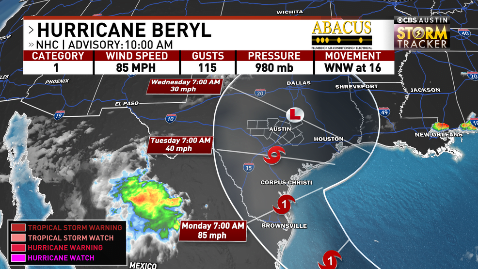
Beryl made landfall in the Yucatan Peninsula Friday morning as a Category 2 hurricane. Due to land interaction, it continues to weaken until it emerges back over warm ocean waters.
Once it does so, there will be a better understanding on the potential track for Beryl. Right now, there is still some uncertainty on where it makes landfall and how strong. Trends continue to point towards a landfalling hurricane somewhere along the Texas coast late Sunday into Monday morning.
For us in Central Texas, models and forecasts continue to shift Beryl further up the Texas coast. If this happens, the heaviest rain would stay east of I-35.
But if it tracks over the region, the heavy rain and flooding concerns would be here. Changes in the track remain crucial for our forecast. Where it does make landfall, those areas can expect life threatening storm surge, hurricane-force winds, and flooding due to heavy tropical rainfall. Areas from Brownsville to Beaumont need to continue to pay close attention to the forecast trends. We’ll really have a better understanding of the potential track once Beryl gets back in the Gulf and better organized.
Be careful this weekend if you’re heading to the coast. You can expect a high rip current risk that can be deadly for swimmers.
Thursday July 4 | 8:30 p.m. Update
As of Thursday evening, Beryl has re-strengthened into a major hurricane. It is expected to make landfall there early Friday morning as a hurricane bringing big impacts to areas like Cozumel and Cancun.
It will weaken some due to land interaction before emerging into the Gulf of Mexico late Friday into Saturday. It is forecast to strengthen over those warm Gulf waters and head towards the northeast coast of Mexico or the southern Texas coast late Sunday into Monday. With how Beryl had defied odds so far… it wouldn’t be shocking if it was able to intensify quickly into a hurricane earlier than expected.
Now the tricky part… there is still some uncertainty on exactly where Beryl will make landfall… but trends continue to nudge the potential landfall a little further north, so landfall somewhere in Texas is increasing. Where ever Beryl makes landfall, it will likely bring hurricane-force winds, deadly storm surge and flooding due to heavy rainfall. Heavy rain could also move pretty far inland and with the system potentially slowing down, inland flooding concerns will continue to increase as well.
Again, there is still some uncertainty this far out on where Beryl will make landfall and what definite impacts it will bring to Central Texas. We will have a better grasp on Beryl and its track towards Texas once it gets into the Gulf of Mexico. Continue to pay attention to the latest forecast updates.
Thursday July 4 | 4 p.m. Update
Beryl officially weakened into a Category 2 late Thursday morning, but is still expected to bring big impacts to the Yucatan Peninsula late Thursday into Friday.
Hurricane warnings are out for Cozumel and Cancun where those areas could experience hurricane-force winds, storm surge, rip currents and possible flooding.
The official forecast track from the National Hurricane Center weakens Beryl even further after landfall with the Yucatan Peninsula before emerging into the Gulf of Mexico late Friday.
Due to favorable warm waters and less wind shear, Beryl is forecast to strengthen into a hurricane before making landfall somewhere along the Mexico/Texas coast late Sunday into Monday.
Something to take note if you live anywhere from the Rio Grande Valley to Corpus Christi is the forecast track and model data continues to nudge the center of Beryl further north. If this trend continues, chances that Beryl makes landfall in Texas increases.
This could mean areas along the Texas coast could experience life-threatening storm surge, hurricane-force winds, coastal and inland flooding due to heavy rainfall. This also means rain and flooding chances increase for Central Texas as well.
It will all be dependent on the track of Beryl once in moves further inland. Since there is still some uncertainty on where Beryl will make landfall, continue to pay close attention to the forecast trends and make sure you’re prepared if you live along the coast.
Wednesday July 3 | 4 p.m. Update
Beryl continues to bring life-threatening storm surge and hurricane-forced winds to Jamaica as the eye of the hurricane is located along the southern shore.
It remains a Category 4 with max sustained winds of 140 mph as it continues to quickly move west-northwest at 20 mph.
Hurricane warnings are out for the Cayman Islands as it will move close there on Thursday.
The National Hurricane Center forecast it to weaken some as it moves near the Yucatan Peninsula early Friday, then emerge back over the ocean waters into the Gulf of Mexico late Friday into Saturday.
Land interaction would potentially weaken the storm to tropical storm status before strengthening once again into a potential hurricane before landfall somewhere near the Mexico/Texas coast Sunday into Monday.
A reminder that this is a fluid forecast and this will continue to change. If you live along the Texas coast, continue to frequently check back with the latest forecast. We’ll know more on where Beryl could be heading over the next couple of days.
Wednesday July 3 | 1 p.m. Update
Beryl has weakened some Wednesday afternoon as it now has 140 mph sustained winds, but still is a category 4.
The center of Beryl is currently just around the southside of Jamaica bringing hurricane-force winds to the island for the the rest of the afternoon and evening.
The National Hurricane Center still has Beryl as a major hurricane through Thursday before interacting with more wind shear that will weaken it even more as it approaches the Yucatan Peninsula by Friday.
Hurricane warnings and watches our out for the eastern side of the Peninsula and a tropical storm watch is now our for the northern and western side.
It will likely make landfall Friday morning as a hurricane before moving into the Gulf of Mexico Friday night into Saturday. As of Wednesday afternoon, the forecast cone includes portions of south and south-central Texas by late Sunday into Monday.
Beryl is still forecast to strengthen back into a hurricane on its approach to either Mexico or Texas. Still too early to determine if and exactly where/how Beryl could impact Texas.
If you live along the Texas coast, continue to frequently check back with the latest forecast. We’ll know more on where Beryl could be heading over the next couple of days.
Wednesday July 3 | 10 a.m. Update
Hurricane Beryl continues its journey through the Caribbean as a powerful Category 4 hurricane.
Beryl is expected to impact Jamaica Wednesday as hurricane warnings are out for the island in preparation for hurricane-force winds today.
It will then start to impact the Cayman Islands on Thursday before approaching Cancun/Yucatan by late Thursday into Friday. A hurricane watch is now out for the eastern side of the Yucatan Peninsula.
BERYL IN THE GULF OF MEXICO
After Beryl moves through the Yucatan Peninsula, it is forecast to move into the Bay of Campeche/Gulf of Mexico by Saturday.
Due to land interaction, it is expected to weaken to a tropical storm. Due to the warm waters in the Gulf and potentially less wind shear, Beryl is expected to strengthen some as stays over the open water.
By the late weekend, the National Hurricane Center is calling for it to re-strengthen into a hurricane as it approaches either Mexico or potentially the Texas coast.
POTENTIAL IMPACTS TO TEXAS?
Now, we are still a couple of days away from this system moving into the Gulf of Mexico and even several days from the system potentially moving into Mexico or even Texas. We’re watching the latest trends very closely that bring Beryl closer to Texas Sunday into Monday.
Latest trends continue to show Beryl curving further north near the Texas/Mexico border rather than moving just into Mexico. If this were to happen, it would have more time over the warm, Gulf of Mexico waters potentially allowing it to strengthen even more.
A stronger system could mean a further north track that could bring bigger impacts to the Texas coast. Impacts would be coastal flooding from storm surge, potential strong wind gusts and torrential tropical rainfall that could lead to inland flooding. Impacts could be far enough to impact portions of Central Texas with rain and gusty winds.
If it has a rougher time over the Yucatan Peninsula, it might be impacted enough to just move further west into Mexico bringing less impacts to Texas.
We still have more questions than answers this far out, but Texans along the coast need to consistently check forecast updates throughout the week.
HOW TO STAY WEATHER AWARE
Download the CBS Austin Weather App for the latest weather updates and information here.
Check here for more CBS Austin Weather forecast updates.


